The three of us had another big day planned. We would start at Spring Creek Pass and make our way to Coney Summit, the highest point on the Colorado Trail, then drop into the Pole Creek drainage where we would find a place to camp. About 10 minutes after leaving camp, we came to a junction with a map and a sign below that said "You Are Here." It was good to know we were there.

In the first 6 miles, we climbed more than 1000 ft., saw a huge flock of sheep with two watch dogs and crossed Jarosa Mesa, another completely exposed stretch of tundra above treeline. The trail on Jarosa Mesa was nonexistent, so we walked from cairn to cairn. We all occasionally looked back to the east and could see Snow Mesa moving further and further into the distance, something all three of us were very happy about.
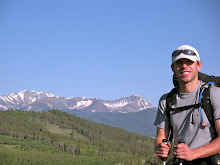
The trail climbed several bumps along the Continental Divide with spectacular views of the surrounding San Juan Mountains. As we made our way towards Coney Summit, the wind picked up around 10 am. Whenever I saw that we were coming up to a gap in the ridge where the wind would really be howling I would take my hat off. I knew if I didn't, it might soon be flying down the mountainside with me trying hopelessly to chase it down. There were several climbs where I would turn my hat backwards when we went into the wind and turn it back forwards at the next switchback. The three of us looked pretty comical leaning into the wind, trying to make headway towards Silverton.
We reached Coney Summit, elevation 13,240 ft., just after noon. We actually didn't even know that we were at a summit. It was more like a little bump on the ridge with the distinction of being the highest point on the 485-mile trail. Trying to keep our sense of humor and find a sheltered place from the incessant wind, we didn't celebrate on top for long. We dropped down 800 ft. in the next mile to Carson Saddle. On the way down, we had to walk a steep, loose section of 4x4 road that we all kept slipping and sliding on. It was time for a break.
The mining remnants in the San Juan Mountains are everywhere. There are old structures from the late 1800's and early 1900's that are still standing even though this part of the Rocky Mountains is notorious for having ferocious winter storms. There are many mountainsides that were once obviously mined with piles of loose rock everywhere. However, the most amazing remnant from the heavy mining times is all the roads. There are dirt roads criss-crossing these mountains in the steepest, seemingly least accessible locations. It is unbelievable to sit above 13,000 ft. and look down on alpine tundra with so much infrastructure from a time past.

After crossing the pass we also crossed the imaginary line marking 20 miles for the day. Robyn and I were feeling good, our bodies adapting well after nearly 3 weeks on the trail. However, this was the point in the day when Keith's foot would start to hurt. When we reached a trail junction with Pole Creek, Keith decided to try the one shoe-one sandal technique. Even though I felt terrible for him because he was hurting, I couldn't help but laugh when I saw him walking down steep, narrow, rocky trail like this. He was incredibly tough and amazingly good-humored. Nothing seemed to ever get him down, not even having to hike with one sandal and one shoe. He was going to make it to Durango. It was great being able to hike with him.
The trail dropped and passed several good campsites with nearby creeks, then headed out along a scree slope up towards another pass. We were all confused. The guidebook pages Kieth had photocopied and the databook all said we should be dropping all the way to Rio Grande Reservoir. That was to the south, but the trail we were on was headed to the west and rolling up and down.
After talking things over and looking at the sun getting closer to the mountainous horizon, we all decided to head back a quarter mile to the last good spot we saw to camp and figure out what was going on there. While we cooked dinner and gathered water, I looked at the topo maps and found we were headed in the right direction. The trail had split away from the Pole Creek drainage. The confusion came because the guidebook and databook said we were supposed to go down the Pole Creek drainage. I was confident the map was right and the books were wrong. We figured there must have been a recent re-routing of the trail and the maps were up-to-date but the guidebooks were not.

The next morning brought more beautiful blue skies. We quickly reached the crest of the pass we were looking at the previous evening and contoured around a small peak. There were cairns everywhere! Many of them were bigger than us. We all agreed our premonition that the trail had been re-routed to avoid the big descent to the reservoir and big climb back up to Stony Pass was correct. I took pictures next to many of the cairns, impressed by the determination and dedication put in by trail crews to make them.
 While dropping down to the middle of a drainage, we came across a group campsite with about a dozen tents scattered about the tundra. The group was there doing just what we thought was happening; they were working on the Colorado Trail trough this new section. Keith, Robyn and I were all relieved to get an official word we were on the right trail. They described to us that the trail followed the Continental Divide for the next 7 miles to Stony Pass. In addition to avoiding the descent to the reservoir and big climb to Stony Pass, this new bypass also avoided the multi-use trail going down to the reservoir. They said the old Colorado Trail through Pole Creek was not very enjoyable. We were very grateful for their efforts to make the trail better.
The ridge walk didn't prove easy, though. We would climb, then descend, then climb, then descend. The trail was steep, rocky, and occasionally nonexistent. However, there were always cairns to follow if the trail wasn't there. When we stopped to enjoy the surroundings, as we often did, we were amazed with the colors in the mountains, the wildflowers all around, and the perfect mountain weather. Things were looking good.
There was a small bit of trail magic after passing Stony Pass. We all grabbed some candy from the bucket hanging off the side of an old mining structure and signed the guestbook. Like the past few days, the wind started to pick up around 10 am. Since we were above treeline, there was no way to get out of it. We all just put on wind breakers and kept moving forward.
There was a small bit of trail magic after passing Stony Pass. We all grabbed some candy from the bucket hanging off the side of an old mining structure and signed the guestbook. Like the past few days, the wind started to pick up around 10 am. Since we were above treeline, there was no way to get out of it. We all just put on wind breakers and kept moving forward.

Arrow and Vestel Peaks came into view as we walked across another mesa above 12,000 ft. We all looked ahead towards Elk Creek, knowing there was huge descent in front of us. The topo map showed the descent as a series of switchbacks all crammed together. The guidebook described it as nothing short of spectacular. We were all excited.
After cresting a small rise, the switchbacks came into view. They zigzagged down an amazingly steep slope. There was a group of people at the top of the descent and as we approached them we saw they were forest service workers fixing trail signs. They had packed their stuff in with llamas and were working on making sure the trail junctions were clearly marked in the area. Keith put down his pack to get a snack before heading down Elk Creek and realized one of the sandals he kept strapped to the outside wasn't there.

"Oh no, I must have dropped my sandal!" Keith exclaimed with the rangers right there. I cringed when he said that, wishing he would not have said that in front of them. She chuckled at him and said she wouldn't make him go get it or fine him for littering. Keith got lucky, even though he was unlucky to lose his sandal. The ranger offered to ship it to him if someone found it and delivered it to the lost and found box at the Forest Service office. For a moment, Keith thought it was a good idea and gave her his business card. Then he realized he lived in Oman and shipping for a single sandal would cost much more than several new pairs of sandals. The meeting was funny, if not a bit tense for a moment and a little awkward.
The drop down Elk Creek was spectacular, just as the guidebook described. We made our way down the switchbacks, then past an abandoned mine shaft and cabin and down the drainage. We came to treeline after 30 minutes, the first trees we had been in since the early morning. It was nice to get out of the sun. However, as soon as we sat down, flies were all over us. It was the first encounter we had with flies. We didn't like it, so we got back up and kept moving.
 That afternoon we hiked down the whole drainage, eventually crossing the railroad tracks of the Durango and Silverton Narrow Gauge Railroad and finding a good campsite along the Animas River. We had dropped 3500 ft. in 7 miles since meeting the rangers and losing Keith's sandal at the top of the Elk Creek Drainage. We had passed several hikers in the last few miles and were extremely happy to be 4 miles from Molas Pass, the place we would catch a ride into Silverton the next morning.
Robyn and I took turns watching the stove while the other went and rinsed off in the Animas River. Keith was sitting on a rock next to the river, cursing at his clogged water filter. I was happy to have Aqua Mira water purifying drops. I have always hated water filters - heavy, slow, and prone to clogging. Keith was impressed that the Aqua Mira drops didn't have an aftertaste after giving up on his filter for the evening. In this case, we were living better through chemistry.
 After eating dinner, one of the hikers we passed a few miles from the river showed up at our campsite. Her name was Debbie and she was also a school teacher. She had hiked the first half of the Colorado Trial the previous year and was finishing the trail this year, going from Salida to Durango. Debbie offered us some of her extra food and had dinner. We all chatted and ended up in hysterical laughter at one point. The four of us were all overtired. It was time to take a day off.
Keith, Robyn and I were out of camp by 6:15 am the next morning. Debbie was still in her sleeping bag as we wished her luck and told her we would likely run into her in the small mountain town of Silverton. She planned a more leisurely morning and figured she would get into Silverton around noon.
After cresting a small rise, the switchbacks came into view. They zigzagged down an amazingly steep slope. There was a group of people at the top of the descent and as we approached them we saw they were forest service workers fixing trail signs. They had packed their stuff in with llamas and were working on making sure the trail junctions were clearly marked in the area. Keith put down his pack to get a snack before heading down Elk Creek and realized one of the sandals he kept strapped to the outside wasn't there.
"Oh no, I must have dropped my sandal!" Keith exclaimed with the rangers right there. I cringed when he said that, wishing he would not have said that in front of them. She chuckled at him and said she wouldn't make him go get it or fine him for littering. Keith got lucky, even though he was unlucky to lose his sandal. The ranger offered to ship it to him if someone found it and delivered it to the lost and found box at the Forest Service office. For a moment, Keith thought it was a good idea and gave her his business card. Then he realized he lived in Oman and shipping for a single sandal would cost much more than several new pairs of sandals. The meeting was funny, if not a bit tense for a moment and a little awkward.
The drop down Elk Creek was spectacular, just as the guidebook described. We made our way down the switchbacks, then past an abandoned mine shaft and cabin and down the drainage. We came to treeline after 30 minutes, the first trees we had been in since the early morning. It was nice to get out of the sun. However, as soon as we sat down, flies were all over us. It was the first encounter we had with flies. We didn't like it, so we got back up and kept moving.


Keith, Robyn and I were out of camp by 6:15 am the next morning. Debbie was still in her sleeping bag as we wished her luck and told her we would likely run into her in the small mountain town of Silverton. She planned a more leisurely morning and figured she would get into Silverton around noon.
The three of us crossed the bridge over the Animas River, then made our way up the well-worn, well-graded trail nearly 2000 ft. to Molas Pass. The climb went quickly as the town pulled us closer and closer. Whenever a town is near on a long-distance hike, it acts like a magnet. When you get close enough, it will just pull you along regardless of how tired and sore you may be.

After an hour and a half, we made it to Molas Pass and Hwy-550. Robyn immediately stuck her thumb out and Keith and I hid behind her. Within 5 minutes we had a ride. The woman who drove us down to Silverton was headed over Red Mountain Pass to climb Mt. Sneffles. She surely could have out-hiked and out-climbed any of us.
Robyn, Keith and I were all beaming when she dropped us off. It was so nice to be in a town after 6.5 days of hiking. We all had a breakfast burrito and lounged in a local restaurant called the Steam and Steel Cafe. It was delicious. There was a hotel nearby with an apartment open that the three of us split. After showering and changing clothes, we all felt like new people. Our resupply boxes were waiting at the post office. We were glad to have made it to town before it closed so we could get an early start on Monday morning but we were all ecstatic to have most of Saturday all of Sunday in town.
Later that afternoon, Keith found Debbie. She was staying at the same hotel as us. The four of us went out to dinner at a local pizza restaurant and ate until we couldn't eat anymore. Robyn and I overestimated our appetites, ordering a large pizza each. This time we could only eat half a pizza each at one sitting. We took the rest of the pizza to go, though, knowing we would be hungry again soon.
The next morning we struggled to get out of bed, but couldn't sleep past 6:30 am. Our bodies had gotten used to waking up with the sun. I watched the British Open on TV, unfortunately seeing Tom Watson lose his lead and eventually a playoff to Stewart Cink. After that, I spent most of the afternoon napping.
That evening Debbie came over and we had burritos for dinner. The four of us enjoyed each other's company and stories. It was always great to meet new people on the trail. This time that new friendship carried over into town but we knew that this evening would likely be the last time we would see Debbie. Keith, Robyn and I planned to hike the final 73 miles from Silverton to Durango in 3 days while Debbie planned to do it in 5.
The trail, and our adventure, was in full gear. We had made the push to Silverton from Salida and all of us had arrived in good spirits. However, as we hung around Silverton and took in the moment, we began to realize that our adventure was also nearing its finish.

The trail, and our adventure, was in full gear. We had made the push to Silverton from Salida and all of us had arrived in good spirits. However, as we hung around Silverton and took in the moment, we began to realize that our adventure was also nearing its finish.


To readers: The three days described here are in many ways the heart of the CT. If you're lucky enough to have the clear skies that we did, you simply won't find better hiking. It is high, open, and stunning landscape which I hope you can catch in Morgan and Robyn's filming (and Morgan's writing!).
ReplyDeleteTo M&R: Sandal-boot hiking is making a huge impact on the thru-hiking community and is the current rage in Oman. I have strong suspicions that it will be much like the walking pole fad. This is a fashion trend that has legs, if you know what I mean!
Too much fun reading your blog! I hope no one reads my account of the same trip on trail journals (shameless plug) which is much weepier and includes almost no names of flowers, peaks, passes since I relied exclusively on you to read the maps. I know there are only three more days of the trip, but don't forget to write the epilogue, and of course, the "To be continues..." line.
Morgan, thanks for posting your trips on The Colorado Trail. Your writings and images are great. Glad you and your friends are enjoying the adventure. Sorry your Guidebook and Databook were out of date and didn't contain the 17-mile Cataract Ridge reroute; our newest Guidebook and Databook cover it. We try really hard to publish up-to-date guides and alert everyone to buy the current books, but we don't reach all users.
ReplyDeleteThanks so much for emphasizing that the Trail is well maintained. Our volunteers and organization put serious energy into keeping the Trail in good condition. It's nice that Trail users notice. Let us know if you'd ever like to be involved; we could use your help.
Bill Manning, Mg Dir
The Colorado Trail Foundation
www ColoradoTrail.org