
Keith and Mike were out of camp 15 minutes before us. After walking down Lujan Creek Road, we caught them while they searched for the trail after walking a half-mile down Hwy-114. We eventually found it across the highway on the other side of a large pullout. It was not a very well-marked intersection. The trail continued into a dewy meadow and passed over Lujan Creek.
After turning to the south, we came upon a styrofoam cooler on the side of the trail. Trail magic again! This time there were sodas waiting for us, but none of us drank any because it was still chilly outside and we had our fix the previous evening. The trail steadily climbed an old, abandoned logging road to a cul-de-sac and climbed 250 ft. in 0.2 miles to a saddle. It was a short but steep section. Whenever a trail gains 1000+ ft. per mile you can count on some chinscraping.
Keith hiked along with Robyn and I down Forest Service Road 876 while Mike walked alone a bit behind us. As we talked about our itineraries, we realized that we would have to pick up the pace a little. I had originally planned on making it to Silverton on Saturday evening, but thought it would be a good idea to get there on Saturday morning so we could get our re-supply from the post office before it closed at noon. To make it, we really had to high-tail it. I figured we needed to cover 30 miles today to give ourselves a small buffer heading into San Juan Mountains where the terrain would be much steeper and mostly above treeline. Keith had never hiked 30 miles in a day before, but was excited by the opportunity.

Mike caught us soon after and the four of us walked together talking about anything and everything. The trail, which was currently on a dirt road, rolled through sagebrush with spectacular fields of wildflowers. There were paintbrush, bluebells, sunflowers, penstemons, asters and geraniums all around. When it came up that I played the banjo, Keith figured we should have a duel with him on the guitar. It would have been fun, but I'm sure he would have left me in the dust.

Walking along the edge of Cochetopa Park towards Saguache Park Road, Robyn and I noticed something rather funny. Keith's pack was not sitting squarely on his back, but angling rather dramatically to the right. We teased him mercilessly. Whenever he looked back at us, we made sure to act like we were filming or taking pictures of him. Most of the time we actually were! Eventually Keith got the pack straight, but not before we all had a few good laughs.
The views around us opened up dramatically. There were mountains in the distance, but the landscape around us was nearly flat for the first time on the entire trail. We took a break under a lone tree for 20 minutes so we could have a snack and get out of the sun. Eventually we got back on our feet and continued down the road until meeting Saguache Park Road. The four of us had covered 15 miles before noon.

All of us were looking for a water source and hoped Monchego Creek would be flowing. It was flowing slightly, albeit across the dirt road with cow patties all around. None of us were that low on water to even consider drinking it. After taking a right turn, the trail rolled up and down for the next several miles through sagebrush and intermittent fields of wildflowers. Mike decided to stop for a break before Ant Creek and wished us luck. His plans were to stop in Creede two days later and he didn't really want to cover big miles on any one day. We didn't think our paths would cross again.
The Colorado Trail Guidebook said this was one of the least scenic sections of the trail and we would be happy to get through it. I disagree. Even though we weren't in the mountains, the views were expansive and the flowers were in full bloom. The trail wasn't very steep for the most part, allowing us to stretch our legs and walk at a nice pace for most of the day. The toughest part of this section was the heat and lack of drinkable water.

Two hours after passing Monchego Creek we approached another saddle. While talking to a couple on the trail, Mike walked up from behind us with a wry smile. His break didn't last long when he realized he needed to keep moving to avoid running out of water with no supply nearby. Robyn and I walked together ahead of Keith and Mike up to the saddle and down the other side. Shortly before reaching Cochetopa Creek, we both took the last sips of water we were carrying. Our timing was spot on.
While coming down the hill to Cochetopa Creek we saw a family that had driven in to spend the afternoon fishing and playing in the water. I felt a certain sense of pride having walked all the way here from Denver while they had driven in. Robyn and I went upstream of them and lounged by the running water. Amazingly, the mozzies were nonexistent. We re-filled our water and gave our clothes a good clean.
Keith came walking towards us with a huge grin on his face. We figured he was happy to see the water, which he was, but he also had a funny encounter with the folks downstream of us. While he was walking down the hill, a woman with the family was changing on the other side of the car from Robyn and I. That side of the car, though, was the side Keith could see. The woman shouted that a hiker was watching her and how embarrassed she was. Keith laughed. He knew she was being paranoid and that it would become another good Colorado Trail story for us.

When Mike came down the hill the three of us were sitting in the grass along the edge of the creek joking about how the woman might come after Keith. We lounged in the late afternoon sun for nearly an hour, enjoying the time off our feet.
There were more miles to cover, though. Shortly before we crossed over Cochetopa Creek on a series of wooden planks, Mike pulled off the trail to setup his camp. This time we wouldn't see him again. We all wished each other good luck. Keith, Robyn, and I were bummed not to have him along anymore, but we knew we had made a good friend. People say that a day spent together on a trail like this is like spending a month together in the real world. You get to know people really well, really quickly.
The walk up Cochetopa Creek was pleasant, but the three of us were getting tired. When we reached the Eddiesville Trailhead and found a great campsite nearby, we stopped to camp without hesitating. We covered more than 30 miles. Keith was smiling, maybe from the accomplishment or maybe because the day was finally over. I think it was a little bit of both.
Robyn and I always split our camp tasks. She would set up the tent and get water while I would cook dinner. We usually had everything set up and dinner ready within half-hour. That evening we had quinoa with veggies and slivered almonds. It tasted unbelievably good. We both ate enormous portions followed by half a bar of dark chocolate.

Day 18 promised to bring more challenges. When we woke up, I was a little nervous to see clouds in the sky before 6 am. Usually that meant thunderstorms were brewing. The day started at 10,32o ft. and the trail would climb to the saddle of San Luis Peak at 12,600 ft. over the course of the first 9 miles. We were entering the San Juan Mountains, the most rugged and remote of all the mountains in Colorado.
After only a few minutes, we crossed into the La Garita Wilderness and were met with imposing views of the mountains ahead. The San Juan Mountains are well known for their rugged beauty and rich mining history. There are only a few towns scattered about the 12,000+ square miles that this part of the Rocky Mountains cover, including Creede, Lake City, Ouray, Silverton and Telluride. In the late 1800's when mining was in full force in this area, there were thousands of prospectors who lived here hoping to strike it rich. Silver, gold, copper, and lead were all found in this heavily mineralized region. Now, though, tourism is the driving force behind local economies with only small-scale mining operations that are very widely dispersed.

The climb up to treeline and the saddle of San Luis Peak was not as steep as we had feared. Our bodies seemed to be adjusting to the daily routine of hiking for 10-12 hours. Bertha hadn't bothered me at all in a few days and Fred and Nigel were not annoying Robyn. She was still dealing with Normalena (her left knee) on the downhills, but even Normalena was not as intense as a week before. We were feeling very good about this positive trend.
The clouds were still lingering as we climbed up and down the mountain ridges. We would drop down several hundred feet on steep, rutted trails only to climb up seemingly steeper, more rutted trails. Even though we were all well acclimated, we frequently had to stop and pant to try to catch our breath above 12,000 ft. It was great fun.
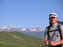
The views around us were amazing. San Luis Peak, a fourteener, stood just above us to the north. Mountain peaks rose all around with red tops stained from iron and green slopes of grasses and shrubs. We continued on. Up, up, up, then down, down, down.
After crossing the West Mineral Creek Trail, we looked out at an open ridge and knew that we would be fully exposed to the weather for the next few hours of hiking. Snow Mesa lay further ahead, a fairly flat 3 mile expanse of tundra at 12,280 ft., with no easy escape from storms. The clouds looked semi-threatening all day, but nothing had happened yet. We decided to go for it.
The three of us moved well in the alpine terrain. I hiked out in front, followed by Robyn, with Keith close behind. We normally hiked in this order and usually there was a bit of separation between each of us. Each of us had a comfortable pace to walk at and breaking that pace to stay close to one another could be quite tiring.
The trail climbed to a saddle the turned to the south where we walked along a flower-covered plateau. Eventually we reached another saddle at a junction with the Old Skyline Trail. The Colorado Trail veered to the west and down to Snow Mesa.

Snow Mesa began as a flat, vast grassy expanse with mountain views in the distance. A towering cumulus cloud lingered to the east. Every time I looked back to make sure Robyn and Keith were doing well, the cloud seemed to be moving in. Fortunately, it stayed far enough away.
Unfortunately, the wind did not stay away. It blew into our faces mercilessly. The only way to combat it was to put our heads down and keep moving forward. The mesa was actually not entirely flat, dipping rather steeply in and out of small drainages. The 55 minute, 3-mile walk proved to be the most unpleasant of the entire trip. We hardly spoke a word to each other and had no way to get any respite from the wind. All of us were glad, though, that we didn't encounter a thunderstorm out there.
Robyn and I were waiting for Keith at the edge of Snow Mesa as he crested the final rise. I filmed him as we were both laughing, completely worn out. Keith thought we were enjoying ourselves but was relieved to find out we both didn't have a good time on Snow Mesa. He later admitted he had pictured the three of us cruising across the mesa side-by-side enjoying the early evening together. That didn't end up happening, but we all made it safely across and kept moving forward.
Keith had developed some blisters over the previous days and was having problems with his foot each day after about 20 miles. The walk down to treeline and Spring Creek Pass was a welcome relief for Robyn and I, but Keith was not in good shape. His foot was searing in pain. He ended up borrowing Robyn's trekking poles for the 2-mile, 1300 ft. descent. All three of us were ready to end a long day.

We could hear cars long before we could see them, but when we made it to Spring Creek Pass we all smiled with jubilation. The parking lot across the highway said the area was for day-use only even though our maps and guidebook indicated it was a campground. There were obvious campsites behind the parking lot. We had nothing left in our legs and there was no more water for several miles, so we put up our tents behind some trees and enjoyed our dinner on the nearby picnic benches. The three of us were all sound asleep before the sky was completely dark.


Pretty goofy walking on my part. I kept thinking, "it takes a crooked man to walk a crooked mile."
ReplyDeleteI'm amazed I ever finished the trail or that you and Robyn weren't embarrassed to walk with me.
What a great read though, with photos that add much and the video clips are perfect!
Eagerly awaiting the next chapter... Keith